So I took a few of the ceramic tile pieces that once graced the River Roads Stix, Baer & Fuller/Dillard’s building back to the spot they formerly occupied. It was easy to set them up in the place they once stayed because the spot remains an empty field, which is both depressing and annoying.
This Once Was What Was Here
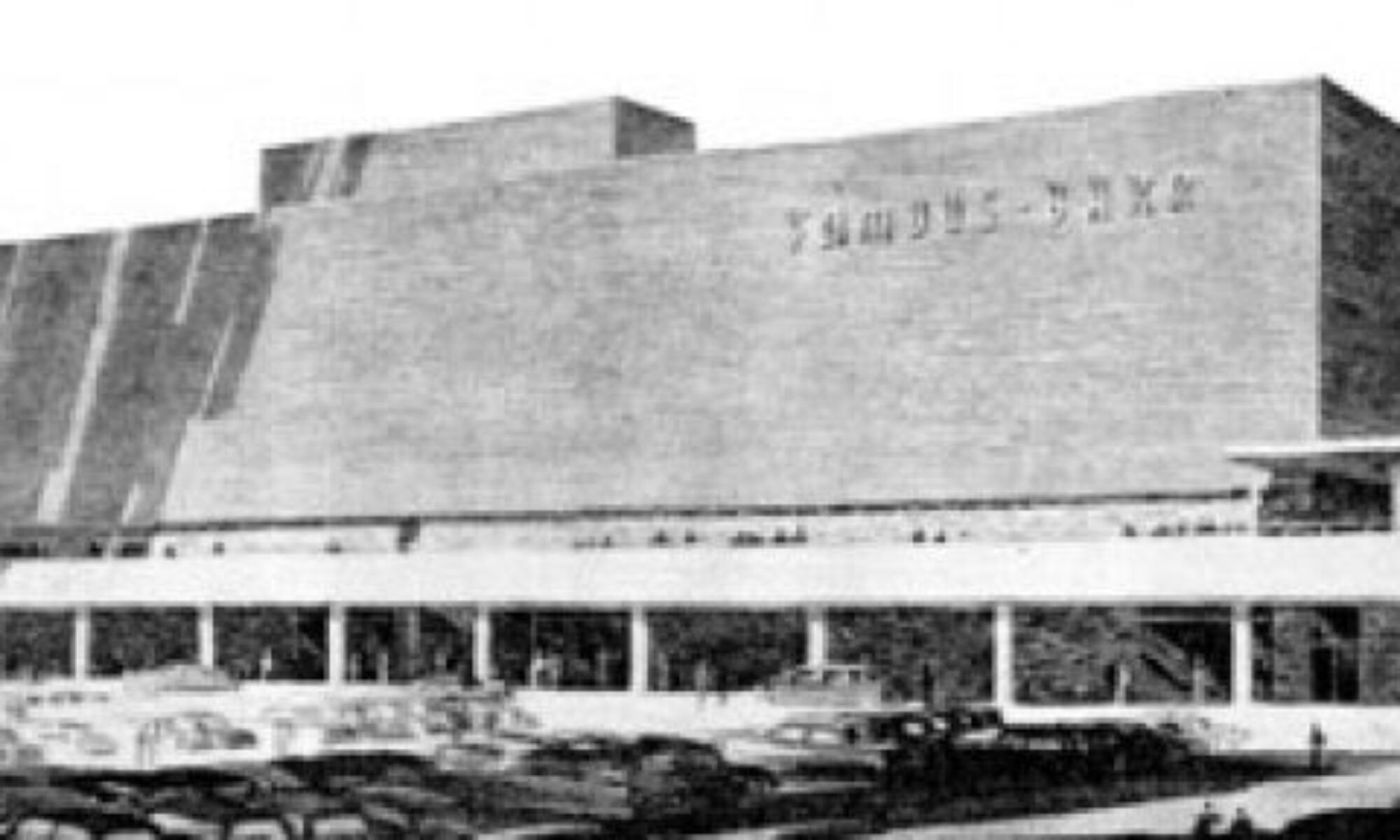
The photo above is from 1961, while River Roads Shopping Center was still under construction. Wikipedia fills in some key facts. But even better is where I borrowed this photo from.
Dwayne Pounds has the River Roads Mall historical photo hook up! I encourage you to check it out here, and understand that I’ll be borrowing from this man’s excellent archival work. Dwayne even put them into YouTube format.
I took this photo in May 2006 just as demolition was beginning. There was nothing to be done about the destruction other than document what was left, which remained beautiful in decay.
Those of us who respectfully trolled the demolition site began referring to this lower level outdoor plaza in front of the former Stix as “the sunken garden.” On the left of the frame is what once was The Pavilion restaurant.
The Pavilion in 1961 before it opened, courtesy of Dwayne Pounds.
And what remained during demolition in October 2006, when destroyed walls made the interior visible once again. Lost Tables shares the ghost of Ladies who Lunched:
When the River Roads store opened in 1961, a separate adjacent building housed the Pavilion Restaurant, open seven days a week for lunch and dinner. Two live trees, eight feet and twelve feet tall, were featured in the glass-walled center section. A pool, with a sculptured marble fountain, added to the garden atmosphere. The main dining room was French Provincial in feeling, with antiqued walnut chairs and star-flecked, deep blue carpeting. An informal patio area had a flagstone floor and wrought iron furniture in pale blue. Lighting was rheostat controlled and could be focused on models when a fashion show was in progress.
The Ghosts Are Watching
After visiting the site with architecture in tow, I ran across this photo album with the Stix, Baer & Fuller price tag still in place.
My best guess of when River Roads changed from a Shopping Center to a Mall is the mid-70s, shortly after Jamestown Mall opened. They stilled billed it as Shopping Center when JC Penney opened in 1972; Jamestown Mall opened in 1974. The history of Stix, Baer & Fuller confirms they officially morphed into Dillard’s in 1984.
Though the corporate wheels were already churning, as this advertisement on a 1983 map of North St. Louis County shows River Roads splitting the difference between both Stix and Dillard’s. The actual map still names the site River Roads Shopping Center because cartographers are not required to keep abreast of the retail marketing landscape.
Also of note is that River Roads Mall only had Dillard’s for roughly two years before it permanently closed at this location. Seniority is why I continually refer to this building as Stix, Baer & Fuller.
I do believe (and please fill me in otherwise) this was formerly the exterior of Walgreens. This photo shows it on the far left in 1961. And while traipising around the demolition site in July 2006, I walked around the corner and saw…
…a good view of the interior of the mall promenade, without having to break in. The Walgreens signage is still hanging. And the clock tower remains! I loved the architecture of the entrance into the mall between the Stix building and JC Penney addition (above). Whomever the project architects were (and that information has yet to surface) were liberally borrowing and paying homage to the Bauhaus modern masters, disguised as a way to keep shoppers dry as they hurried into the mall for new shoes.
As demolition began, they dragged the long-buried contents inside the Stix building out into the light. Like this pink chair from the beauty salon. I have shots of rusted hair dryers in the brutal summer sun that still delight.
This entrance on the northern side of the Stix building had become abstract art by May 2006.
When the demolition crew punched a hole in this same wall in October 2006, some of us were able to grab a few pieces of those gray and turquoise tiles. I deeply loved those architectural elements, and eventually turned them into borders for flower beds, which I dubbed the River Roads Memorial Garden.
Because I visit NoCo on a regular basis, I kept track of what became of the River Roads Mall site. By July 2009 (above) they’d cleared the western portion of the lot, and since the Food For Less (formerly Krogers) was now closed, it was moments away from being demolished.
9 years later on August 2018, Dollar Tree and a couple of other stores have taken their place, while the western edge remains empty and grassed over.
There had been all kinds of grand plans for the River Roads Mall site. During demolition, they erected senior living apartments along Halls Ferry Road, on the site of what once was parking for the mall. Then came the 2008 Economic Crash, and the original re-developers going bankrupt, and there’s White Flight Economics which neurotically devalues anything white people abandon, and…
Elliot Davis caught up with another thwarted development of the unused property in February 2017. It’s depressingly ironic that Kroger – who was the original grocery store at River Roads Shopping Center – wanted to come back and couldn’t.
The old Boatman’s (ghost) Bank at Halls Ferry Road and Cozens Avenue was demolished in Spring 2008. But the vast majority of the River Roads Shopping Center site remains a field of grass.
Stix, Baer & Fuller is a field of grass, making it easy to pull up to an unused curb and prop up old portions of the building that once was.
I understand the economic theory that decaying buildings have to come down to make it easier to entice new developers to the land. Though I dearly wish North St. Louis County would try out Historic Tax Credits for their iconic properties that now qualify rather than tear it down for a ghost town.
Think about this: if the Stix River Roads building remained standing until 2011, it would have most likely qualified for Historic Tax Credits and could have been remodeled into apartments. Which is a far better outcome than having remnants of what once was serving as ornaments in my carport container garden that took a nostalgic ride back in time.
May 30, 2005 was the very first B.E.L.T. entry. 10 years later, the title of the maiden post ironically sums up my current mindset about the state of my relationship with St. Louis:
As a person who trends to the positive because it has more power for meaningful change, I’m not comfortable with the cantankerous and curmudgeonly state of mind I’m currently in about my beloved hometown. Rather than prattle on in the negative, I prefer to say nothing at all. This is why new postings have been scarce throughout 2013 and most of 2014, and came to a complete halt after expressing my feelings about #Ferguson in September 2014.
But a 10-year anniversary of a blog is a special thing, especially in the ADD cyber world, so I want to acknowledge my relationships with this blog, this town and the people who have been a part of this journalistic journey. So to quote an overzealous 5th grade classmate who was picked to lead our physical education class for the day: “10 jumping jacks! Ready? BEGIN!”
An Outlet for an OCD Photo Habit
I wanted to be like Julius Shulman, and happily went down that path with several years of serious dark room lurking over black and white film of St. Louis architecture, grand and unassuming (like the example above, of the former Mark Twain Theater in Sunset Hills, MO). Then I got a digital camera. Film vs. digital is the equivalent of espresso vs. cocaine, and I went on an epic bender.
I believe there should be a purpose and/or outlet for creative expression, so felt a burning need to do something with this stockpile of images. This need coincided with blogging going mainstream. I started my first blog, M.E.L.T. in March 2005.
With some kindly coding help from Perez Hilton and Trent Vanegas (Pink is the New Blog), I got the knack and shared thoughts about my lifelong obsession with pop culture and celebrity.
M.E.L.T. was the necessary blogging due diligence and learning curve to get to what really mattered – St. Louis buildings, grand and unassuming. I still clearly remember the joyous moments I discovered Ecology of Absence, Urban Review STL and Built St. Louis. These men and their output were inspiring, fascinating and entertaining. I felt I had something to offer about our town’s built environment that wasn’t covered by them, so it would not be a pale imitation of their work, nor step on their areas of expertise.
A Mid-Century Modern Cheerleader
The launch of B.E.L.T. created a place to share photos and stories of my travels around St. Louis, and beyond. It was also the opportunity to dig deep into the demise of Northland Shopping Center, in Jennings, MO, that had both deep personal meaning and important historical context about mid-century modern architecture coinciding with the development of St. Louis County.
While all eras of St. Louis architecture matter to me, it’s the architecture from roughly 1940 to 1970 that resonates strongest. Those are the photos and stories I shared the most, and the buildings I worried about the most. MCM architecture was too young to yet be properly appreciated by the preservationists and general public, while also being too old for developers and the general public to care about. In 2005, Northland Shopping Center and Busch Stadium were the biggest examples of MCM disregard leading to demolition.
I felt an urgent need on two fronts:
To call attention to the last important era of American architecture, with the hopes that the preservation communities would catch on and get behind protecting the best examples.
Photographically capture and share as many of our local examples as I could before they disappeared.
Much to my surprise and eternal gratitude, it wasn’t hard to sell. Turns out there were plenty of St. Louisans who understood and agreed with my agenda. They were generous with information – hipping me to things to check out, or filling in missing details – and enthusiasm.
B.E.L.T. sometimes helped to make it easier for us like-minded folk to protect or celebrate MCM architecture.
Protection-wise, a large group of us went up against an arm of the St. Louis Archdiocese to save the San Luis in 2009. We lost the fight (and the building), but learned valuable lessons about how to handle future threats.
In retrospect, it really didn’t take long for the City of St. Louis to get on board with saving worthy mid-century buildings. One great example: By Spring 2013, Missouri gave us an award in Jefferson City for helping to save the Grand Center Saucer (with the original architect, Richard Henmi, in tow!).
Celebration-wise, a Spring 2010 post about an Atomic Crash party in Indianapolis ended with a question about doing something similar here in St. Louis. The first 4 commenters on this post became founding board members of what became – and remains – Modern STL.
Because of B.E.L.T. I’ve been honored to be invited to take part in symposiums, seminars, lectures, exhibits and documentaries, tours and film screenings (hello Julius Shulman!). And most astoundingly of all, esteemed people who actually are architectural experts because they have the education, experience and encyclopedic minds have repeatedly referred me to as an “authority” on St. Louis mid-century modern architecture.
No disrespect to any of them when I say, “Man, you’re soooooo wrong!” I am not an authority, by any measure. I am only a storyteller who illustrates the tales with photos. I am only a cheerleader for an architectural style that needs proper respect. The beauty of the little big town of St. Louis (and the internet) is the ability to reach the key people who actually can, and do, make a positive difference. To quote Freddie Mercury, “I thank you all.”
But It’s Been No Bed of Roses
By 2013, there was many fine people, blogs and organizations covering St. Louis architecture – and MCM specifically – that my compulsion to cover it relaxed. My slacking blog entries wouldn’t cause any harm because others had the wheel. So I took the time to pursue another lifelong passion – music – and that is an ongoing staple of my free time (shameless plugs: The Remodels & The Jans Project).
Then there was August 9, 2014. On that Saturday, as Michael Brown was shot down in Ferguson, I was about 1.5 miles away in neighboring Jennings, showing someone a street where I once stayed. To an outsider, they were shocked at the state of decay and disrepair of the streets and homes. Seeing it through their eyes – rather than with my typical nostalgia and loyalty to North County – I was stunned and saddened. Later that night, I learned of what happened to Michael Brown, and I was heartbroken.
From that moment on, the events that transpired in Ferguson radically altered my perspective. What was the point of rallying to save a building (the Lewis & Clark Library in neighboring Moline Acres) when the people of North County were in turmoil? Many buildings in Ferguson and Dellwood were sacrificed to the anger. I was compelled to talk about in this post. But in the face of systemic injustice to some of our people, I lost the heart to talk about buildings.
Come November 24, 2014, with the grand jury decision not to indict Officer Darren Wilson, I was sickened and in tears as Ferguson and Dellwood burned. It truly felt as if the Powers That Be were purposely letting it be destroyed to make a convoluted point.
Since then, 3 things are really pissing me off:
Football Is More Important Than You: Governor Jay Nixon – who had to be dragged into inept action about Michael Brown’s death in North County – couldn’t move fast enough to potentially wipe out part of the North City riverfront to build a new football stadium. And telling us that we had no voting rights about partially funding a new stadium because we’re still paying for the current stadium. And this boondoggle trail is already muddied by crooked money. Why is it that every 20 years we have to pony up so a select group can make even more entertainment dollars?
Causing Destruction to Save You: The City of St. Louis is lobbying to demolish occupied North Side homes and businesses so the National Geospatial-Intelligence Agency might remain in the city because, supposedly, the NGA’s tax money and employment is more important than that which is already there. Why not 2-bird-1-stone it and use the vacant Pruitt-Igoe site for this project? Or is that not owned by Paul McKee?
And Enough Already!
These are the St. Louis thoughts that lately occupy my mind. This is why it’s better I say nothing at all. Anger and criticism is easy to cave into, but it leaves me feeling inappropriate and rotting, a disillusioned Pollyanna.
There are St. Louis built environment happenings that are surprising and cool. For instance, the Northwest Plaza redevelopment is, so far, an interesting balance of original buildings with new construction and uses (above, under construction, April 2015). And all the modern in-fill housing and mixed-use buildings slated to go up around The Grove in South St. Louis is life affirming. Jennings called a quick halt to Family Dollar wanting to take down a Frederick Dunn church on West Florissant, and then found another tenant for the church.
But I can’t muster the energy to cover those things. I’m trying to muster up the courage to photographically cover the demolition of the Lewis & Clark Library (being dismantled, above, April 2015), and reeling from the irony of the failed effort winning an award. I don’t know if I have it in me to watch another beloved and worthy building go down needlessly, much less share the story with others. It’s probably best to just grieve in private, over this and all the other St. Louis people and places that trouble me. I count on this being a momentary phase, please.
Some Stats, Acknowledgements & Forecasting
In 10 year, there have been 437 B.E.L.T. entries (or 438, counting this one). Google Analytics reports these are the Top 10 most-read posts:
Here are the Top 10 posts with the most comments from readers. Only 3 overlap with the most-read, so can we conclude these are of most interest to us locals? (Note: I disabled comments on the West Florissant White Flight post to avoid the hatred. People still found ways to get ‘em in, though.)
St. Louisans are so heart-warmingly generous with information, and love to share their knowledge. Along with post comments, I have received so many wonderful emails from so many helpful people. To everyone who provided pieces of the puzzle, thank you a million times for caring and sharing.
B.E.L.T. also made it possible to meet so many amazing, enthusiastic people who care deeply about St. Louis, and I’m eternally grateful for those that became good friends and fellow adventurers. So many of these posts double as a personal scrapbook of good times I had with great people.
Thank you to any organization or publication that bestowed an award upon B.E.L.T. and/or its author. That’s way cool. And to all the journalists who asked for my thoughts or assistance, thanks for believing St. Louis buildings are newsworthy.
As for the future… I bet I post again. Like I said, I hope the “you kids get off my lawn!” phase is a temporary affliction. And I am exploring the world of podcasting. The St. Louis built environment would definitely be a reoccurring topic, providing a chance for you to hear from some of the St. Louisans who’ve enriched my blogging experiences.
Here we recap the article’s content with room to spread out, and add more engrossing details uncovered during the research process.
Masters of Sex depicts Maternity Hospital as a sublime, stucco Art Deco.Maternity Hospital, erected 1926, still stands in the Barnes-Jewish Hospital complex at Kingshighway and Interstate 64.
The series opens in December 1956 with the newly-divorced Virginia Johnson interviewing for her eventual position as Dr. William Masters’ assistant. Master’s office is in Maternity Hospital, shown as a handsome Art Deco hospital of white stucco. That was the first instance of TV separation from St. Louis reality, for the 1926 Maternity Hospital still stands today inside the Barnes-Jewish Hospital complex.
Dr. Master’s office and practice was on the 3rd floor of this building, and other than the exterior facade and some molding and terrazzo flooring touches at the entrances, everything has been remodeled countless times since the 1950s. Very little about Master’s and his ground-breaking work remains within the record books of the hospital or Washington University. Local theory is that ultra-conservative St. Louis academia still finds it offensive to acknowledge his pioneering sex studies. Though his last name does make the list of blocks inside the circular wall of this outdoor smoking lounge in front of the building (below).
Still with the first episode, we see Dr. William Masters and his wife Libby living in an exquisite mid-century modern ranch home, which for 1956 would have put them on the cutting edge of St. Louis modern design, something a successful doctor could afford to indulge in. Meanwhile single-mother-of-two Virginia Johnson is shown living in one side of a 2-story, stucco duplex. Other than some more stucco (St. Louis just doesn’t have the climate for it), this type of living arrangement for Virginia is logical. So are these homes based on their real life domiciles, and if so, where are they?
Masters of Sex exterior establishing shot of St. Louis brothel where Dr. Masters conducted research.
Episode 2 of Masters of Sex really lit a fire when they gave an establishing exterior shot of a local brothel (above). But it was a bit disconcerting that this was the 3rd or 4th time that wood clapboard homes were shown as the norm. Even to the distracted eye, St. Louis is a brick city – we don’t see wood siding as a constant until the post-WW2 suburbs. And it’s a cinch that a whorehouse would have to be inside St. Louis City boundaries, where a home of this type would be very rare.
I was distracted with these type of architecture geek thoughts when the thoroughly engaging prostitute character Betty DiMello revealed that the sex study had moved “to a cathouse on Third & Sutter.” I waited for the episode to end before digging into maps of both St. Louis and East St. Louis, where there is no such intersection. So exactly where was this whorehouse?
It was now time to dig into the source material for the TV show, the 2009 book Masters of Sex: The Life and Times of William Masters and Virginia Johnson, the Couple Who Taught America How to Love by Thomas Maier. It’s a factually dense book that easily moves you forward with anticipation. And this book sent me into obsessive research mode, deciphering fact from TV fiction.
As the first season unfolded, it was addictive to figure out how the show’s creators and writers took the original and transformed it into an episodic drama. How a one-off sentence in the book becomes a story-arc, or how two different real life people are melded into one character with a completely fictitious yet fascinating backstory.
The mid-century modern ranch designed by architect “Eine,” home to the TV version of Dr. William & Libby Masters.The interior TV set of The Masters’ home.
One of the most revelatory differences between fact and artistic license is the home of Dr. William and Libby Masters. The viewer gets a distinct Mad Men vibe from their clean-lined, suburban mid-century modern ranch home. Maier’s book describes their real-world house as a “brick two-story Colonial” in “Ladue, an affluent suburb of St. Louis.” And here is their former home, built in 1934:
The real life home of Dr. William & Libby Masters, in Ladue, MO.
The show’s producers made a conscious decision to place William & Libby in a new, atomic age home. They also added an infertility problem to their marriage, whereas in real life, they had two children by 1953. But one fact did remain intact: Libby & Bill did sleep in separate twin beds! (And here’s a gossipy fact: they installed an in-ground pool to this home in 1967, and the neighbors were scandalized to see Virginia Johnson lounging by it while Libby was out of town.)
Other deviations from fact to television fiction include:
• There’s no Provost Scully (as portrayed by Beau Bridges); he’s a combination of a few men at Washington University, including Chancellor Ethan Shepley.
• There’s no real-life prostitute Betty DiMello, which means it’s unlikely anyone ever called Dr. Masters the “alpha dog of coochie medicine.”
• Dr. Ethan Haas and Gene The Pretzel King are made up characters (so there is no Gus’ Pretzel connection to Masters & Johnson, sorry)
• St. Louis has yet to have a Rialto movie theater (so the entirely fictitious Dr. Austin Langham never banged the entirely fictitious Margaret Scully in a car parked in front of it)
• St. Louis never had a Gardell’s, described in the show as a “nightclub in Coontown” (though senior citizen St. Louisans can tell you the rough whereabouts of the part of town once referred to by that wince-inducing moniker).
• St. Louis never had a Commodore Hotel where gay male prostitutes set up shop. There were plenty of other gay haunts in the City during that time period (like the Grandel Square Hotel once at 3625 Grandel Square; the Golden Gate bar on Olive Street and Entres Nous on Pine Street), so the creators appear to have condensed that St. Louis scene into one convenient package.
According to Maier’s research, there was most definitely a cathouse where Dr. Masters conducted research. He writes about how St. Louis Chief of Police H. Sam Priest protected Masters (who delivered their second child) so he could conduct studies in local brothels. Chief Priest and his detectives found willing candidates among prostitutes and made sure they were not busted in the weeks before and after the testing.
Maier writes, “Between 1955 and late 1956, Masters expanded his study in such St. Louis neighborhoods as the Central West End to interviews with call girls in other American cities, such as Chicago, Minneapolis and New Orleans.”
Ah ha! We have a locale on the brothel!
But it’s not like old City Directories are going to list them as such, or old newspapers are going to report any fine details about raiding them. And since I had other questions needing clarification, I reached out to Thomas Maier, who was refreshingly friendly, helpful and prompt in his replies.
The duplex Virginia Johnson lived in, as depicted on Showtime’s Masters of Sex.A real-life example of the home Virginia Johnson lived in after her 1956 divorce. Her actual home was in the spot of the modern condo shown to the left of this home.
By the early 1960s, Virginia Johnson moved into this ranch home in Salem Estates in Ladue, MO, a “traditional subdivision” designed by St. Louis architect Ralph Fournier.
As learned from Maier, the Masters of Sex producers have yet to visit St. Louis, which explains the architectural discrepancies. While filming the pilot, the producers found a mid-century home in Huntington, NY that they liked, and later reproduced it on Sony’s Hollywood lot. An old wing of the Jamaica Hospital in Queens, NY stood in for Maternity Hospital. And even though the scenes set on the Washington University campus looked authentic, it’s actually the former Guggenheim estate in Long Island, NY.
He also only knows the general location of the whorehouse as Central West End. Dang it!
I am a life-long, ardent participant in the suspension of disbelief that is Hollywood. But the first season’s episodes aired while I was deeply consumed by Maier’s book and my research, and I found myself second-guessing and dismaying over the deviations from Masters & Johnson’s actual story. Which kinda killed my buzz – totally of my own doing. But it did not keep me from watching and thrilling to every episode, it only clarified that I need to apply more effort to maintain my Hollywood vs. Reality balance.
And the producers’ decision to put Dr. Masters in an MCM ranch did eventually pan out in real life:
The mid-century modern ranch in Ladue, MO that Dr. William Masters & Virginia Johnson moved into after their 1971 marriage.
Above is the home, built in 1951, that Bill & Gini (since we got this far, it’s OK to use their nicknames, right?) moved into after they were married in 1971. Oh please oh please let the series go on long enough to get to that soap opera plot twist!
Anyway, this home became a place for their more famous or notorious clients to stay for therapy, avoiding possible detection at the more public Reproductive Biology Research Foundation office at 4910 Forest Park Blvd. (long-since torn down). From the book:
The Ladue house on South Warson Road was more contemporary than most, sheltered by tasteful plantings that shielded activity from the street. Upon entering, guests walked into a vestibule and could follow one of two ramps – to a spacious dining room and kitchen on one side, and to several bedrooms on the other, including the master suite with two king-sized beds placed together. In the back of the house were a large terrace, a kidney-shaped inground pool, and a stable with enough surrounding acreage for Johnson’s daughter, Lisa, to ride her horse. When Cindy Todorovich later bought the South Warson house, she found a secret panel with a peephole. “I’m not saying there was anything kinky going on, but maybe it had something to do with their research,” she recalled.
Apartment building at Maryland Avenue & North Taylor in St. Louis’ Central West End, home of Dr. Masters’ mother, Estabrook.
The book also has some fun facts that seriously need to go into the series.
The apartment building shown above is where Dr. Masters’ mother, Estabrook, moved to after she was widowed. The child abuse and transformation of his mother’s personality as shown in the series is true. What also needs to be shared is that the staff of Masters & Johnson’s Repro Bio office often spent their lunch hours at Estabrook’s apartment on the 8th floor, because it was a nice walk to and from the office. And since she was now privy to the details of their work, she helped out by sewing silk masks for study volunteers to wear to protect their anonymity.
So Where’s the Brothel?
I made endless inquiries to pinpoint the locale of this place (or places). Librarian friends at both the St. Louis City and County libraries worked on it (along with providing assistance in digging up old phone book and directory information – thanks Adele!), and I followed all leads about anyone who knew a cop or a friend who had brothel info.
Elder St. Louisans mused that a brothel in St. Louis city couldn’t have existed for very long without being busted, and they certainly wouldn’t have been in such luxurious quarters as shown in the screen cap earlier in this post. And the 1952 book U.S.A. Confidential by Jack Lait & Lee Mortimer verified that there was an “overpopulated harlot population” in St. Louis, including “a lot of call-girls” moving “into the new Ford Apartments.”
It was the friend of a friend who verified that a city brothel just wouldn’t be all that glamorous. Roland Kulla is a St. Louis native now living in Chicago, and he shared the following memories and photos from when he lived in the eastern border of the Central West End:
“I lived at 3850 Olive St. near the Vandeventer Ave. intersection, from 1947-1954. The street was very busy then – lots of shops, and bars and a small department store across the street, the streetcar line ran down Olive. We lived in an apartment above my uncle’s bakery, Sausel’s (new-born Roland is shown with his family in front of that bakery, above) where my father worked. Stories about the brothel next door at 3848 came from my mother, as I was too young to know.
“The buildings on that corner formed a courtyard in the back. You came through a yard to get to the back door. Our back doors were right next to each other – although there was a wooden fence between them (photo below). Mom told the tale that sometimes the clients would knock on our door by mistake.
Roland Kulla and his friends in front of the fence that separated their yard from that of the brothel next door.
“(The brothel situation) had changed by 1954 when we moved, as there was a legit neighbor there that we were friendly with. The layout of the apartment, which would have been similar to the one next door, was a small bedroom in the front over the stairs. There was a double parlor – the front one with a fireplace – divided by sliding doors. We used both parlors as bedrooms, with the small one used the nursery since there was always a new baby. Beyond that was a hall bath, and then a big dining room that went the width of the building. And then a big kitchen in the rear with two walk-in pantries.”
3848 Olive was the site of a St. Louis brothel from 1947 – 1954.The rear of the buildings (since demolished) on Olive. A wood fence separated 3850 from the brothel at 3848.
Roland took the two photos above in the early 1990s. The buildings were completely demolished about 10 years ago, with only The Lighthouse of The Blind building (which formed the east flank of the rear courtyard) remaining on the block.
We are in no way implying or supposing this was the location of Dr. Masters’ laboratory, especially since it was cleaned up prior to beginning his local field studies in 1955-56. It does verify that such places existed, and for long stretches of time, and they were not opulent.
My hope is that I will eventually run across a retired St. Louis City cop who worked under Chief Priest, or had passed-down knowledge of assistance for Dr. Masters, and that so much time has passed they are willing to talk location details. If you’re as curious as I am about finding Bill’s cathouse, and know someone who knows these kinds of things, please let me know. The seedy underbelly of St. Louis was deep and vivid, and in this particular case, led to major scientific discoveries that permanently and positively altered the sexual landscape. If those brothel buildings still stand, they deserve an historic marker, don’t you think?
The real life Virginia Johnson and Dr. William Masters.
Glasgow Village is a perfect example of an inner ring suburb that sprung up along the City of St. Louis border in the early 1950s. On this map, you’ll see that the last thread of the City boundary (Ward 2) hugs Riverview Drive. When they began developing this land along the Mississippi River bluffs, St. Louis City fire and police personnel were eager to have the homes being built within city boundaries to meet residency requirements. Stories are that they would offer more than the asking price just to have them.
Concurrently, the adjacent County land that is Glasgow Village (early history here) was also being developed. St. Louis County directories show only 3 streets in existence in Glasgow Village in 1951. By 1955, it was complete and filled with homes much like this.
Adhering to the “village” in its name, the new community needed a central commerce gathering place, and construction of Glasgow Village Shopping Center (shown in the map above) began in 1957. There were spots for 15 businesses, including the backside of the building which was accessed on foot.
The 1959 County directory (above) lists the original tenants. Many of these shops regularly contributed to the various Glasgow Village newsletters released by the trustees and the local schools.
Shops like Connie’s Village Dance Studio (which became Marion’s Village Dancing School by 1963) contributed to the close-knit village atmosphere that still prevails in the hearts of GV ex-pats, who regularly converse and contribute at Glasgow Village Friends.
The towering, angular sign at the corner of the shopping center long served as the striking symbol of the village.
And it still stood tall and proud in 2003 when I took the photo above. By then, the majority of the center was vacant, with the liquor store at 104 Glashop Lane (isn’t that a great street name?) pulling in a brisk business. But even in its reduced state, it was easy to understand how vital this place once was to the town.
By its siting, GV is rather remote, which was a great selling point during the suburban migration of the early 1950s. The shopping center became an instant “downtown,” taking care of just about all of the residents’ needs, and all within walking distance.
104 started off as Zimmerman’s Glasgow Pharmacy, part of the Rexall dynasty. And the dry cleaner’s shown above made the news in 1968 when it caught fire.
The Italian American Delicatessen at 108 (above) morphed into Cusumano’s Village Inn by 1974.
And that storied pizza place lives on in O’Fallon, MO. Exactly when they left the shopping center is best left to the memories of the GV Friends, and hopefully they will chime in with comments here. Just as they recently shared information that some of the Cusumano family showed up to watch the demolition of the center. Which is a testament to how much this place meant to everyone who lived there.
The St. Louis racial divide as it pertains to real estate has been deeply documented, with Mapping Decline being the most exhaustive resource for information on the whys and hows of White Flight and Redlining. Even though the federal government stepped in to ban the practice, the mentality still seems ingrained, transferring from North St. Louis City to North County, and requiring more recent intervention.
But there is never just one reason for decline, so lets look beyond St. Louis’ racial tensions. Along with rapidly advancing conspicuous consumption from the 1980s to mid-2000s that led to ever-bigger homes in far-flung locales, I think there’s topography at play in North St. Louis County.
Starting with the first settlers in 1764, St. Louis development always favored the southern half before the northern half for one very logical reason: the north is very hilly because the ancient confluence of the Missouri and Mississippi Rivers created mountainous mass. When it came to build and all you had were shovels and cattle-driven plows to move earth, you’d naturally choose the flattest terrains first.
This hilly topography later limited placement of interstates during the 1950s – 60s, and the rivers are a definitive end to the area. All of these factors combine to give far North St. Louis County a remoteness that does not exist in West and South County, where they can – and do – keep expanding. Look to the fate of Jamestown Mall to understand why through traffic is crucial for retail. It’s also crucial for keeping neighborhoods lively. The more pocketed communities tend to stagnate, and Glasgow Village is, sadly, a perfect example of this.
The iconic sign was a poignant focal point on February 25, 2013 when St. Louis County Executive Charlie Dooley held a press conference in front of the cranes in front of Glasgow Village Shopping Center. He announced an increased budget to demolish an initial 41 buildings in North County, mostly fire-damaged and vacant homes that had become nuisance properties. GV residents verified that the shopping center had become an insurmountable problem for their community. And so they demolished Glasgow Village Shopping Center.
The County plans to take down more than 100 buildings this year. Glasgow Village Shopping Center was the perfect way to make a dramatic media splash about the “aggressive program.” I have yet to see posted a list of all the properties due for demolition. Even though Doolie stated that “we recognize that we cannot demolish our way to neighborhood stabilization,” a lack of information on what buildings are coming down is troubling. Parts of the City of St. Louis have yet to recover from aggressive demolition during the mid-century Urban Renewal. I hope that the County does not repeat these errors with a misguided Suburban Renewal program.
There was interest in saving the Glasgow Village Shopping Center sign because it is such a powerful symbol of the community. But the demolition company did not have the budget to take it down in a manner that preserves it. Reports came in that once it hit the ground, it was dragged for a bit which damaged the porcelain face of the signs.
The Glasgow Village trustees did cart off one side of the sign that was relatively unscathed. I love the sentimentality that compelled them to save a last remnant, and am keen to know what they plan to do with sign.
There was nothing but torn concrete and straw by the time the photo above was taken on March 9, 2013. Too long a physical reminder of better days, the shopping center is now officially a memory.
Does anyone know of any solid plans for redeveloping this site?
Creating something new and vital here should be as important of a priority as erasing the problems. I understand why demolishing buildings gets media attention, but I hope Doolie and his team will continue to engage in public dialogue about their plans and progress. North County deserves a fighting chance for renaissance.
…this sign. And that fact was consigned to the memory of a select few until it was brought to light by Dean Wieneke. Read his story here.
The beauty of the world wide web is that anyone can find anything, and the family of the men who were Dickerson Motors found the story of Dean finding their family’s sign. They got in touch with me both in comments on the blog entry and personal emails. Which lead to them graciously scanning old photos, which are shared with you now.
Julie Dickerson Chung and Carolyn Dickerson Zerman are the daughters of William E. Dickerson, who started Dickerson Motors, Inc. in 1951 with his brother Thomas E. Dickerson (whose son Don Dickerson provided some of these photos). It was a Lincoln Mercury dealership located at 6116 Natural Bridge Avenue. It was in the shadow of the only remaining gasometer in St. Louis.
Here is that spot today. Note that the building appears to have been sitting on the dividing line between St. Louis City and County.
Dickerson by day…
…and by night. These photos were taken shortly after the dealership opened.
A big day for Dickerson Motors was when actress and icon Debbie Reynolds stopped by the dealership in 1955 to buy a car. She was on her way back to California to marry singer and actor Eddie Fisher.
Above, Bill Dickerson hands Debbie Reynolds the keys to the car she chose. To put it in historical context, Miss Reynolds had just completed filming of the movie The Tender Trap, with Frank Sinatra. It would release in November of 1955.
And Debbie gets inside her new ride to zoom off and marry Eddie Fisher. The marriage would produce actress/author Carrie Fisher, and end tragically when Eddie left Debbie for Elizabeth Taylor in 1959. This is just how her history played out and in no way infers her car from Dickerson Motors played any part in future marital dramas.
Don Dickerson (son of co-owner Tom Dickerson) shared the photo above, depicting the “Hot Rod Lincoln” that was part of the dealership’s racing team. In conjunction with the racing team, Don recalls:
“Before a race, my Dad was out zooming around Missouri to see what the Lincoln could do. He came over a hill at a very high speed and found that at the bottom of the hill was a buckboard with two horses pulling it. He slammed on the brakes but was going too fast to stop, killing two horses and totaling the car.”
To the best of Carolyn Dickerson Zerman’s memory, the car dealership closed around 1957-58. “I know my sister Julie was born around that time and was a “saving grace” to my Dad (above left), who hated to see the dealership close.”
The family does not know what became of the sign after Dickerson closed. In this entry about Ackerman Buick, former employee Tim Von Cloedt said Jerry Ackerman bought out Kuhs Buick on North Grand Avenue and moved the whole shebang out to Dellwood in the early 1960s. The first building on the lot went up in 1964 – so did the sign, now recycled as Ackerman Buick.
Where was the sign from 1958 to 1964? Considering how much information we’ve received so far, there just may be someone out there who knows the answer.
And this whole saga came to light when Dean and his family bought and dismantled the sign (above) to put it in storage at his father’s farm. As of this writing, Dean sold the sign to Fast Lane Classic Cars in St. Charles, MO, who plan to hang it on the side of one of their buildings.
So St. Charles is the newest chapter for one of the busiest, most recycled signs in St. Louis history. And thank you to all of the Dickerson family for being so generous with their photos and information.
This post about Top of the Tower Restaurant from October 2007 is by far the most-commented entry I’ve ever done. Within the comments, we hear from the granddaughter of Tower’s developer Bud Dallavis, as well as several people who worked there over the years. We learn that it did NOT spin (people confuse it with the former Stouffer’s restaurant in Downtown St. Louis), and a few people share the recipe for Rizzo’s famous Spinning Salad.
A post comment from the end of July 2011 set off alarm bells: Michael Collins went on an adventure inside the Top of the Tower building, and made it all the way to the top and inside the long-vacant Rizzo’s Top of the Tower. He even took pictures! I pounced on him like a puppy to a chew toy, and he gladly consented to share his photos on Facebook so they could be shared on B.E.L.T. All of the photos you will see here were taken by Michael with his cell phone.
The elevator in the Tower lobby no longer goes up to the top floor, but the stairs do. When Michael got to the top, the door to the restaurant was wide open, “and there were no signs stating no trespassing, although I’m sure they don’t really want anyone up there. I don’t really recommend going up there for your own safety.” He told of some strange encounters with questionable people (and dogs) during his time in the building, so I’m heeding his advice, and very grateful that he chanced it, took these photos and shares them to add to the history of a beloved North County restaurant that continues to be held warmly in the hearts of all who went there.
After the adrenalin high of sifting through his photos, I was feeling like Peggy Lee asking “Is that all there is?” This is what the mythical place actually looked like? Really.
My overall impression of Rizzo’s interior is what I call Spanish Bachelor. It’s a term I use to describe a late 60s/early 70s design plague in swingin’ suburbia. It was a hearty embrace of EZ Brick, Chianti bottles with candles stuck in ’em, blackened wrought iron (real or fake), dark distressed wood, masculine-colored velvets, corduroy pillows and macrame plant holders. It was a look favored by heterosexual single men, and we’d have to ask one of the survivors of this faux-rustic 16th Century Spanish matador design decision what it was meant to convey.
I never imagined that the penthouse showcase of the magnificent mid-century modern tower – all pink metal tubular sleekness – would look like this. In the photo above, the wood paneling on the window columns feels right for a place that opened in 1964.
I’m assuming the ceiling was originally white so that the coffers radiating out from circle center met up with the paneled columns to create a starburst effect.
But the rest of this….?
OK, the place has been vacant for a long time, but we can overlook the neglect to get a sense of what was. And I’m getting the impression that lots of remodeling went on over the years. Or that there was one major sweep of a re-do in 1975…
…because this wallpaper IS 1975 personified. And it has held up rather well, don’t you think?
There is the fantasies that those of us who weren’t alive/participating in that era have, and then there’s reality. My fantasy for Top of the Tower might look a bit more like this series of photos. And maybe it did back in the day. Remodeling and updates happen organically over time, and restaurants – particularly – have to stay somewhat current and fresh to remain open. So we see a wide hodge podge of design fads piled atop one another.
Obviously, the restaurant conveyed differently with furniture and lighting. Have you ever seen your favorite bar during the day, exposed to natural and overhead light? Then you know there’s a real magic to low lighting at night. Cocktails help everything along, of course.
But in all the memories that have been shared about Rizzo’s Top of the Tower, it was never about the decor (though the views were a major treat). It was the people who worked there, the excellent customer service, the superior quality of the food, and the sense of specialness all of these things combined created for everyone who went there. We’re now looking at what remains of a place long separated from its magic.
A major batch of thank you goes to Michael Collins for making these photos available to us.
And for all of you who once worked there or ate there on a regular basis, could you please tell us about how the place looked over the years? What did it look like when it opened? What kind of changes were made over the years?
Maybe seeing these photos will spark you memories and you’ll share in the comments as copiously as you did previously. If you have photos to share, that would be excellent, too.
South Kingshighway Blvd & Arsenal
South St. Louis, MO
Found it!
Well, kind of.
The 1964 addition of the former Southwest High School (now the Central Visual/Performing Arts High School) once sported a notorious mural. A portion of its lush exoticism can be seen above. The mural was an identifier – of a neighborhood, of an area and a great marker when giving driving directions. Shortly after the public school became a magnet in the mid 2000s, they painted over the mural with a dull dark brown that attempted to mimic the brick. The irony of quashing vivid artistic expression on the wall of a creative arts institution was not lost on anyone.
Once the public art was gone, folks like myself who track the built environment started looking through our files to find any pictures we may have taken of the mural. I know I have a full-on shot of it from the mid-1990s because I used to live across the street from the place, and remember walking over to it, purposely to document the mural. For those of you who spent decades shooting film, you also know you have boxes upon boxes of photographs, and who has the time to sift through all that? But it’s been bugging me for far too many years: where’s that mural photo?
While looking for something else, I ran across this photograph. Because of the concert poster in the bus stop shelter (also known, briefly, as a Cher Chapel), the photo was taken in the early summer of 2002. This brief glimpse of the Southwest High School mural removes finding the better photo from my To Do list. Well, kind of.
If any of you know the origins of the mural and the decision to blot it out, please do share in the Comments.
West Florissant & Hwy 270
North St. Louis County, MO
St. Louis hasn’t seen the likes of a Venture sign since 1998. But for the holiday shopping season, much like Gypsy Rose Lee peeling and dropping a glove, Venture teases us with a blast from the past.
One question though: after 12 years, Kmart still won’t spring for real signage? Nice job, class all the way.
Shreve & Lexington Avenues
North St. Louis City, MO
The St. Louis City Talk blog pegged these houses above when covering the Kingshighway East neighborhood (scroll down 40%), and when I said to Matt Mourning that I wish I knew exactly where they are, he said, “I told you about them in January. They’re at Shreve and Lexington.” Within a couple days, Chris Naffziger and I were taking in this scene. St. Louis bloggers do not mess around (except when they forget something told to them 10 months ago – what a drag it is getting old!)
There’s actually 2 perfect rows of these houses, back to back on Lexington and Palm, creating an entire block of mid-century bungalows between Marcus and Shreve. All of them are 1,104 square feet, built between 1962-63, according to City records. The Lexington side also extends one block to the west, where the homes face Handy Park, with half of them of the same vintage, but with a few design variations and a little more space, clocking in at 1,173 s.f. These new homes were labeled the North Cote Brilliante Subdivision.
What makes the compact block of North Cote Brilliante so intriguing is what is across the street from them. Shown above is a good sample of what the residents of the 4700 block of Lexington see when looking out the floor-to-ceiling windows of their mid-century pads. These brick boxes date from 1911-1912, and none of them go over 725 s.f. This is standard for this era of single family homes in this area. It’s the mid-century homes that are out of place, in the best way possible.
Take a look at the aerial map and you see how different they look from their neighbors, with no alley dividing the backyards, and their bright, low-pitched roofs contrasting with the flat roofs all around them. Considering the history and density of the area, it’s natural to assume that similar homes were demolished to build the new houses. But why did they choose to demolish that particular block – plus another near-dozen across from the park – to insert new homes?
So began the research through old City Directories, which showed nothing at all at these addresses even as far back as 1921. In fact, in 1921, Shreve didn’t even exist as a street south of Natural Bridge, and Palm ended 10 blocks east at Clay Avenue.
A 1958 aerial map confirms that the sites in question were indeed blank, with Handy Park taking shape at this time. Turns out Handy Park was dedicated in June 1960 in honor of songwriter W.C. Handy, who matters greatly to blues music, in general, and matters specifically to our city because of his seminal 1914 classic “St. Louis Blues.”
The City made the ordinance to turn this land into a park in 1941, and even at the dedication 19 years later, the houses overlooking the park (shown above & below) were still 3 years away from being built and bought. So why were there sizable swaths of blank land in the middle of this neighborhood for so many decades?
Tired of pouring through books at the library, I took a delayed shortcut and called my father, Richard, to ask what was up with that part of Kingshighway East. His immediate answer: Handy Park was once a quarry. He remembered being 8 or 9 (which would be 1940 or ’41) and going with his parents to visit their friends who lived at Lexington and Aubert Avenue, and being specifically told not to go near the quarry which had recently been closed because some boys had been killed while exploring the site. For roughly 15 years, they filled the site with cement and stone to get it to a point where they could build the park.
His recollection of time period jived perfectly with the City park ordinance, and a quick cyber search verified that indeed there was an awful lot of quarry right there, as shown in the pink dot on the 1904 quarry map, above. According to Stone Quarries and Beyond, it was known as First Quarry, one of three owned by John B. O’Meara. The official address was at Euclid and Ashland Avenues, and limestone was pulled from it starting in 1876.
Which means that these homes on Palm – dating from 1926 to 1935 – had a quarry or a vacant dirt lot as their view until…
…these homes popped up in 1963.
It’s heartening to know that nothing was demolished to make these small, swanky homes, and it’s intriguing that many homes of this type were going in the North Side. For example, Norwood Square – just 1 mile west of here – went up on the site of a former trash dump. And similar homes (which can be seen here at St. Louis Patina) went up on always-vacant land on both Carter and Anderson Avenues – about 2 miles northeast of here – between 1952 to 1961. There’s also San Francisco Court that went up in 1957, and which will be covered in a future B.E.L.T. post.
There was a sizable chunk of new post-war housing being built in North St. Louis, yet all the various versions of St. Louis City history never mention this, even in passing. These new developments were a big deal to the people living in the area. In fact, on this block that you see above, there still resides two original residents who moved in to them when they were brand new in 1962. And note that most of them are in really good condition, which is evidence of decades worth of constant maintenance.
These houses were a big deal then, and they still matter today. Yet they don’t rate a mention in the developing history of North St. Louis. The story is told as if nothing new and inspiring went on in North St. Louis after World War 2. With a sidelong glance to the Urban Renewers, Red Liners and Paul McKee’s of St. Louis, I ask:
Why is that?
Globe Drugs
2626 Cherokee Street
South St. Louis, MO
The Cherokee Street News broke the news that the venerable Globe Drug store had closed its doors, and got the sentiment right in the headline: 1939-2010. It does feel like a friend has died.
I was expecting a mass outpouring of reports and condolences in the St. Louis press, but so far, only the RFT has jumped on the tragic news. Thank you.
After the initial shock, my first thought was of Sandy Cohen, the son of the Globe Empire begun in 1939. Sandy was born into this store, and it’s the only job he’s ever had. His enthusiasm and love for his working retail museum never seemed to waiver, and if – from his perch in the pharmacy – he noticed you taking pictures and reveling in the atmosphere, he’d cheerfully offer to take you on a tour.
Sandy would point out that the place was a 905 liquor store before his family took over, and iron grills over the vents in the ceiling confirm that this 1913 building was the home of a long-gone, sorely missed St. Louis cheap buzz tradition, from 1937 – 1953.
A Sandy tour gave you backstage access, which in this case is a ride in the original, unadulterated freight elevator up to the 2nd floor. The door loudly slid open to reveal a vast, dark area used for storage, with still-decorated Christmas trees and unopened Easter baskets scattered about.
And then comes the reveal of a bowling alley?
Sandy wasn’t quite sure if there actually was a bowling alley in the building, or if this was just a rescued relic from elsewhere that found a permanent home in the Globe Museum.
The business office truly was a scrapbook of the history of the Globe, and of the Cohen family, both blood related and extended.
The rendering of the St. Louis cityscape (above) was commissioned by Joe as a way to feature all 4 Globe locations. As of this writing, the variety store on South Broadway near Soulard, and the wholesale warehouse at Clark & Tucker in downtown St. Louis remain open. The Globe variety store a couple of blocks west of 2626 Cherokee closed in the mid-90s.
Among the hundreds of photos on the walls is a shot of this store when it was 905 Liquors.
And here’s the same ceiling fixture still in place today.
One of Sandy’s favorite mementos is a letter he received in 2008 from someone confessing to having stolen candy from the store when they were 10. They apologized and sent along this dollar to pay for what they took.
Globe Drug was one of those rare birds: a still-vibrant, direct link to the past. History has personal meaning when you can physically trace the connections and experience a small slice of what life was like before it hit warp speed, before it was corporate, before rat-a-tat gloss suffocated neighborhood personality.
We’re at the reverse of needing to advance the population; the earth is suffering the damage of too many people at one time. So the modern need for offspring seems an instinctive drive for immortality. Globe Drug felt like a slice of immortality, St. Louis style. I can feel the heavy sadness of Sandy Cohen and family as they pack up 57 years of life and cart it out of this building. And even as the neighborhood comes back to life all around it, all of us will feel the emptiness as we pass by 2626 Cherokee.
From a Suburban Journals article on the office wall:
“Who says that you can’t go back? In the “hurry, hurry” world of today’s super conglomerate drug stores, Globe Drugs…stands proudly as proof that quality and commitment to its customers needs still make a difference. …the Cohen family has worked hard to keep the nostalgic atmosphere that you would have found when FDR was in the White House… So, go back. Go back to a time when a variety store was the cornerstone of a community.”


 I loved the architecture of the entrance into the mall between the Stix building and JC Penney addition (above). Whomever the project architects were (and that information has yet to surface) were liberally borrowing and paying homage to the Bauhaus modern masters, disguised as a way to keep shoppers dry as they hurried into the mall for new shoes.


